Archaeology, Geology and Ancient Texts in Search of a Lost River
Introduction
Few subjects in Indian archaeology generate as much discussion as the Ghaggar–Hakra River. Today, much of this river system consists of seasonal streams and dry river channels stretching across Haryana, Rajasthan, and Pakistan’s Cholistan Desert. Yet scattered along these ancient channels lie hundreds of archaeological sites belonging to one of the world’s earliest urban civilizations.
Could this dry river system once have been a major river that supported thriving Bronze Age settlements? Could it be connected to the Saraswati described in the Rigveda? These questions have inspired decades of research involving archaeologists, geologists, hydrologists, satellite specialists, and historians.
While important discoveries have been made, the debate remains active. Understanding the evidence—and its limits—is essential for appreciating both the achievements of ancient Indian civilization and the scientific process through which history is reconstructed.
What Is the Ghaggar–Hakra River?
The Ghaggar originates in the lower Himalayan foothills and flows through Haryana and Rajasthan before fading into the desert. Across the international border, its dry continuation is known as the Hakra, extending through Pakistan’s Cholistan region.
Today, much of this system is seasonal, carrying water mainly during the monsoon. However, broad dry channels visible across the landscape indicate that substantially larger river systems existed in the past.
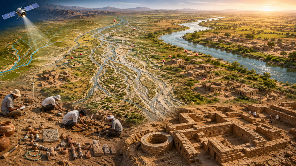
These ancient channels, known as paleochannels, preserve evidence of former river courses that no longer carry permanent flow.
A Landscape Filled with Ancient Settlements
One reason the Ghaggar–Hakra attracts so much attention is the extraordinary concentration of archaeological sites located along its course.
Major sites include:
- Rakhigarhi
- Bhirrana
- Kalibangan
- Banawali
- Farmana
- Kunal
- Balu
Together with many smaller settlements, these sites suggest that the region supported extensive agricultural and urban communities during the Early and Mature Harappan periods.
The distribution of settlements indicates that dependable water resources once existed across much of the region, although the exact nature and timing of those water sources continue to be studied.
What Does Satellite Imagery Reveal?
Modern satellite imagery has transformed the study of ancient landscapes.
Remote sensing has identified broad paleochannels extending across Haryana, Rajasthan, and Cholistan. These buried channels are often much wider than the seasonal Ghaggar River visible today.
Such discoveries demonstrate that large rivers flowed through parts of this region in the geological past. Researchers combine satellite imagery with sediment analysis, geomorphology, and drilling to reconstruct how these river systems evolved over thousands of years.
Geological Evidence
Geologists have proposed several models to explain the history of the Ghaggar–Hakra system.
Some studies suggest that major Himalayan-fed rivers, such as the Sutlej or the Yamuna, may once have contributed water to channels in this region before changing course through natural river migration.
Other research indicates that, during the period when Harappan settlements flourished, the river system may have depended primarily on monsoon-fed flows rather than direct Himalayan glacier sources.
Because different studies emphasize different lines of evidence, there is no single universally accepted reconstruction of the river’s history.
Is This the Saraswati of the Rigveda?
The Rigveda describes the Saraswati as a significant river associated with settlements and ritual life.
Many researchers have explored whether the Ghaggar–Hakra paleochannels correspond wholly or partly to the river remembered in these ancient texts.
Supporters of this interpretation point to:
- the alignment of archaeological sites,
- ancient river channels visible through satellite imagery,
- and the geographical descriptions preserved in early literature.
Other scholars argue that the textual descriptions, geological timelines, and hydrological evidence do not yet establish a definitive identification.
As a result, the relationship between the Ghaggar–Hakra system and the Saraswati described in the Rigveda remains an active area of multidisciplinary research.
Why the Debate Matters
The debate is about much more than identifying a river.
Understanding ancient river systems helps researchers explain:
- where people chose to settle,
- how agriculture developed,
- how trade routes emerged,
- how cities were sustained,
- and how environmental change influenced civilizations.
The decline or transformation of river systems may also have contributed to changes in settlement patterns during the later phases of the Harappan civilization.
What Archaeology Clearly Shows
Although interpretations differ regarding ancient river systems, several conclusions are well supported by archaeological evidence:
- The Ghaggar–Hakra region contains a dense concentration of Harappan settlements.
- Many important sites are located outside the Indus River basin.
- The civilization occupied an extensive geographical area across present-day India and Pakistan.
- New discoveries continue to refine our understanding of settlement patterns, chronology, and environmental adaptation.
These findings have encouraged many researchers to adopt broader terms such as Indus–Saraswati Civilization, while others continue to use Harappan Civilization or Indus Civilization.
Frequently Asked Questions
What is the Ghaggar–Hakra River?
It is a river system extending through Haryana, Rajasthan, and Pakistan’s Cholistan Desert. Much of it is seasonal today, while ancient paleochannels indicate larger rivers existed in the past.
Is the Ghaggar–Hakra the Saraswati River?
Some researchers consider it the most likely candidate or part of the river remembered in the Rigveda, while others conclude that the available evidence remains inconclusive. The question is still being actively researched.
Why are so many Harappan sites located here?
The concentration of settlements suggests that reliable water resources and fertile landscapes supported ancient communities, though the exact hydrological history continues to be investigated.
Why is this debate important?
It helps researchers better understand the geography, environment, and development of one of the world’s earliest urban civilizations.
Conclusion
The Ghaggar–Hakra debate illustrates how archaeology and earth sciences work together to reconstruct the past. Satellite imagery, sediment studies, archaeological excavations, and ancient literature each contribute valuable pieces of evidence, but no single discipline provides all the answers.
What is beyond dispute is that the Ghaggar–Hakra region was home to a remarkable concentration of Harappan settlements and played a major role in the development of Bronze Age civilization in South Asia. As new discoveries emerge, our understanding of these ancient landscapes will continue to evolve, reminding us that history is not fixed but continually refined through evidence.
Cross-Website Links