📖 Part of the Indian Civilization Reborn Research Project
This article is part of the ongoing research behind the forthcoming book Indian Civilization Reborn by Dinesh Chandra Rawat. The book brings together more than 35 years of field research, historical investigation, archaeological studies, international travel and interdisciplinary exploration to better understand the evolution and continuity of Indian civilization.
Did Satellites Really Discover the Saraswati River?
For generations, the Saraswati River was known mainly through ancient Indian literature. Many believed it was a symbolic or mythical river because no large river by that name exists today.
The arrival of modern satellite technology has changed the conversation.
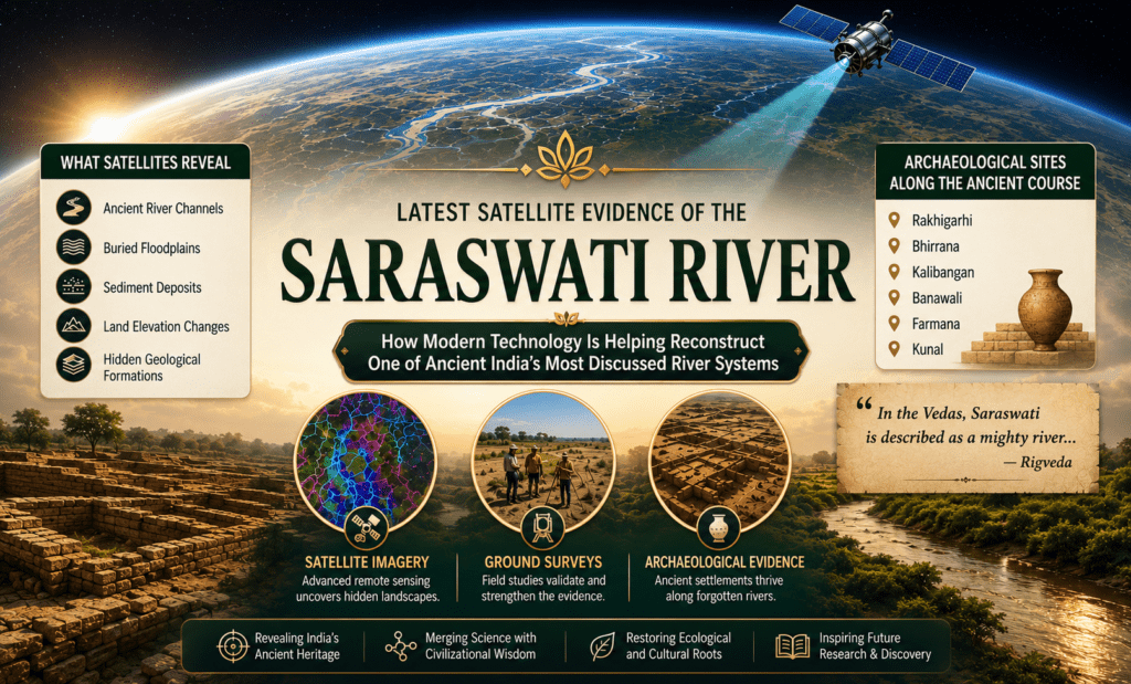
Remote sensing, geological investigations and archaeological discoveries have revealed extensive buried river channels beneath the deserts of northwestern India. While researchers continue to debate whether these palaeochannels correspond exactly to the Saraswati described in ancient texts, there is now substantial scientific evidence that major river systems once flowed through this region.
How Can Satellites Detect Rivers That No Longer Exist?
Modern satellites observe much more than ordinary photographs.
Using infrared imaging, radar, digital elevation models and thermal sensing, scientists can detect buried landscape features that remain invisible to the naked eye.
These technologies reveal:
- Ancient river channels
- Buried floodplains
- Sediment deposits
- Changes in land elevation
- Hidden geological formations
When combined with field surveys, these observations help researchers reconstruct landscapes that disappeared thousands of years ago.
Understanding Palaeochannels
A palaeochannel is the preserved course of an ancient river that no longer carries water on the surface.
Over thousands of years, rivers may:
- Change direction
- Dry up because of climatic shifts
- Become buried beneath sand and sediments
- Merge with other river systems
Although invisible today, their paths often remain preserved underground and can be identified using satellite imagery and geological investigations.
What Have Scientists Found?
One of the most significant discoveries has been the identification of a vast palaeochannel extending through present-day Haryana, Rajasthan and into Pakistan’s Cholistan region.
This buried river system closely follows the dry Ghaggar-Hakra basin, an area containing hundreds of archaeological sites associated with the Indus–Saraswati Civilization.
Researchers have also identified:
- Wide ancient floodplains
- Multiple abandoned river courses
- Layers of river sediments
- Extensive underground water-bearing zones
- Evidence of changing river systems over thousands of years
These findings suggest that the region once supported much larger river systems than those visible today.
Archaeology Strengthens the Picture
Satellite imagery alone cannot prove history.
However, when combined with archaeology, the evidence becomes much richer.
Several major archaeological sites are located along these ancient river corridors, including:
- Rakhigarhi
- Bhirrana
- Kalibangan
- Banawali
- Farmana
- Kunal
The concentration of settlements along these palaeochannels indicates that dependable water sources once supported thriving communities in this region.
Scientific Studies Beyond Satellite Images
Researchers now combine multiple scientific disciplines to understand the ancient river system.
These include:
- Geological mapping
- Sediment analysis
- Groundwater studies
- Isotope analysis
- Remote sensing
- Geomorphology
- Archaeological excavation
- Climate reconstruction
Together, these approaches provide a more complete picture than any single method could achieve.
What Do Ancient Texts Say?
The Rigveda, one of the oldest surviving texts in the world, describes Saraswati as a mighty river.
The river is also mentioned in:
- The Mahabharata
- Several Brahmana texts
- Later Sanskrit literature
Whether these literary references describe the same river system identified through satellite imagery remains an active area of scholarly investigation.
Is the Debate Over?
No.
Several interpretations continue to exist.
Some researchers believe the satellite evidence strongly supports identifying the buried river system with the Saraswati described in ancient texts.
Others suggest that the palaeochannels represent multiple ancient rivers whose relationship to the literary Saraswati is still uncertain.
Most scholars agree on one important point:
Northwestern India once contained much larger river systems than those flowing there today.
The remaining questions concern chronology, river evolution and historical interpretation.
Why This Discovery Matters
The significance of these discoveries extends far beyond one river.
They help us better understand:
- Ancient settlement patterns
- Early agriculture
- Climate change
- Human migration
- Urban development
- The environmental history of northwestern India
Modern satellite technology has transformed the study of ancient landscapes, allowing researchers to investigate questions that were impossible to answer only a few decades ago.
Key Takeaways
- Satellite technology has revealed extensive buried river channels in northwestern India.
- These palaeochannels indicate the presence of large ancient river systems.
- Hundreds of archaeological sites are located along these ancient channels.
- Geological, archaeological and remote sensing studies together provide valuable evidence about the region’s past.
- The exact relationship between these river systems and the Saraswati described in ancient literature remains an active field of research.
Frequently Asked Questions
What is a palaeochannel?
A palaeochannel is the preserved course of an ancient river that no longer flows on the surface.
Can satellites identify ancient rivers?
Yes. Remote sensing can reveal buried river channels, floodplains and geological features that are difficult or impossible to observe from the ground.
Did satellites prove the existence of the Saraswati River?
Satellite imagery has identified ancient river systems in the region. How these relate to the Saraswati described in ancient texts remains the subject of ongoing research.
Why are archaeological sites important?
The location of ancient settlements along buried river channels provides valuable evidence about where reliable water sources existed in the past.
📖 Continue the Journey
This article presents one aspect of the ongoing Indian Civilization Reborn Research Project.
The forthcoming book Indian Civilization Reborn expands upon these topics with detailed archaeological evidence, maps, timelines, illustrations, scientific studies and historical references collected over more than 35 years of independent research.
Coming Soon
Author: Dinesh Chandra Rawat
Publisher: Glories of India Publications
About the Author
Dinesh Chandra Rawat is an author, independent researcher and environmentalist. For more than three decades, he has travelled extensively across India and the world, visiting historical sites, museums and archaeological locations while studying the evolution and continuity of Indian civilization through evidence-based research.